Satellite#
from cider.datastore import DataStore
from cider.satellite import Satellite
We first load some datasets - whose paths have been specified in the config file - using the datastore. The satellite module will by default try to load antenna/tower coordinates, shapefiles defining (administrative) boundaries, the Relative Wealth Index for the country of interest, and population density raster data.
# This path should point to your cider installation, where configs and data for this demo are located.
from pathlib import Path
cider_installation_directory = Path('../../cider')

datastore = DataStore(config_file_path_string= cider_installation_directory / 'configs' / 'config_quickstart.yml')
satellite = Satellite(datastore=datastore)
Loading antennas...
Warning: 10 antennas missing location
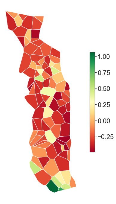
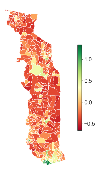
The module can aggregate the RWI - which provides an asset index measure at a resolution of 2.4km x 2.4km - at one of the geographic levels provided by the antennas/towers, in which case their voronoi tessellation will be used - or one of the loaded shapefiles.
In this case, we have loaded (synthetic) data for the country of Togo, and for aggregations at the tower level we will run:
satellite.aggregate_scores(dataset='rwi', geo='tower_id')
while for cantons, admin level 3 in Togo, we will run:
satellite.aggregate_scores(dataset='rwi', geo='cantons')
../../cider/satellite.py:152: RuntimeWarning: invalid value encountered in double_scalars
  score = (score * pop).sum() / pop.sum()
The table is also saved as a geojson, storing the identifier of each region, its score - in this case its Relative Wealth Index - its population, and its geometry.
import geopandas as gpd
gpd.read_file('../../cider/outputs/satellite/maps/cantons_rwi.geojson').head()
| region | score | pop | geometry | |
|---|---|---|---|---|
| 0 | 1 | -0.283597 | 16017.569922 | MULTIPOLYGON (((0.75228 6.83786, 0.75137 6.840... |
| 1 | 2 | -0.413565 | 4367.875125 | MULTIPOLYGON (((0.69026 6.80602, 0.69627 6.806... |
| 2 | 3 | -0.394428 | 9757.760028 | MULTIPOLYGON (((0.63102 6.74430, 0.63295 6.747... |
| 3 | 4 | -0.420952 | 2884.407900 | MULTIPOLYGON (((0.67259 6.85123, 0.67714 6.849... |
| 4 | 5 | -0.112190 | 2907.861156 | MULTIPOLYGON (((0.75269 6.84116, 0.75137 6.840... |